U.S. flag

An official website of the United States government

Here’s how you know

Dot gov

Official websites use .gov
A .gov website belongs to an official government organization in the United States.

HTTPS

Secure .gov websites use HTTPS
A lock (LockA locked padlock) or https:// means you’ve safely connected to the .gov website. Share sensitive information only on official, secure websites.

Emergency

This is not the current EPA website. To navigate to the current EPA website, please go to www.epa.gov. This website is historical material reflecting the EPA website as it existed on January 19, 2025. This website is no longer updated and links to external websites and some internal pages may not work. More information »

    • Environmental Topics
    • Air
    • Bed Bugs
    • Cancer
    • Chemicals, Toxics, and Pesticide
    • Climate Change
    • Emergency Response
    • Environmental Information by Location
    • Environmental Justice
    • Greener Living
    • Health
    • Land, Waste, and Cleanup
    • Lead
    • Mold
    • Radon
    • Research
    • Science Topics
    • Water Topics
    • A-Z Topic Index
    • Laws & Regulations
    • By Business Sector
    • By Topic
    • Compliance
    • Enforcement
    • Laws and Executive Orders
    • Regulations
    • Report a Violation
    • Environmental Violations
    • Fraud, Waste or Abuse
    • About EPA
    • Our Mission and What We Do
    • Headquarters Offices
    • Regional Offices
    • Labs and Research Centers
    • Planning, Budget, and Results
    • Organization Chart
    • EPA History
    • Staff Directory

Breadcrumb

  1. Home
  2. San Juan Watershed

Basic Information about the San Juan Watershed

map showing the location of the San Juan River along the borders of Colorado, New Mexico, Utah, and Arizona
The San Juan River and encompassing rivers.
The San Juan River is approximately 355 miles long, and originates in the San Juan Mountains in southwestern Colorado. It flows westerly into New Mexico and is detained in the Navajo Reservoir. The river continues into southern Utah and ultimately terminates in Lake Powell in Utah. Lake Powell lies on the Colorado River, along the Utah-Arizona border. At 186 miles long and with 1,960 miles of shoreline when full, it is the second largest manmade reservoir in the country.

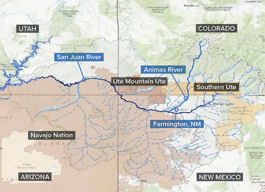
The 126-mile long Animas River originates in the mountain peaks northeast of Silverton, Colorado. It flows southward and into the San Juan River in Farmington, New Mexico.

San Juan Watershed

  • Basic Information
  • State and Tribal Projects
  • Resources for the Watershed
  • Monitoring Data and Map
Contact Us About the San Juan Watershed
Contact Us About the San Juan Watershed to ask a question, provide feedback, or report a problem.
Last updated on March 6, 2024
  • Assistance
  • Ayuda
  • Arabic
  • Chinese (simplified)
  • Chinese (traditional)
  • Aide
  • Asistans
  • Korean
  • Assistência
  • Russian
  • Tulong
  • Vietnamese
United States Environmental Protection Agency

Discover.

  • Accessibility Statement
  • Budget & Performance
  • Contracting
  • EPA www Web Snapshot
  • Grants
  • No FEAR Act Data
  • Plain Writing
  • Privacy
  • Privacy and Security Notice

Connect.

  • Data
  • Inspector General
  • Jobs
  • Newsroom
  • Regulations.gov
  • Subscribe
  • USA.gov
  • White House

Ask.

  • Contact EPA
  • EPA Disclaimers
  • Hotlines
  • FOIA Requests
  • Frequent Questions

Follow.