U.S. flag

An official website of the United States government

Here’s how you know

Dot gov

Official websites use .gov
A .gov website belongs to an official government organization in the United States.

HTTPS

Secure .gov websites use HTTPS
A lock (LockA locked padlock) or https:// means you’ve safely connected to the .gov website. Share sensitive information only on official, secure websites.

Emergency

This is not the current EPA website. To navigate to the current EPA website, please go to www.epa.gov. This website is historical material reflecting the EPA website as it existed on January 19, 2025. This website is no longer updated and links to external websites and some internal pages may not work. More information »

    • Environmental Topics
    • Air
    • Bed Bugs
    • Cancer
    • Chemicals, Toxics, and Pesticide
    • Climate Change
    • Emergency Response
    • Environmental Information by Location
    • Environmental Justice
    • Greener Living
    • Health
    • Land, Waste, and Cleanup
    • Lead
    • Mold
    • Radon
    • Research
    • Science Topics
    • Water Topics
    • A-Z Topic Index
    • Laws & Regulations
    • By Business Sector
    • By Topic
    • Compliance
    • Enforcement
    • Laws and Executive Orders
    • Regulations
    • Report a Violation
    • Environmental Violations
    • Fraud, Waste or Abuse
    • About EPA
    • Our Mission and What We Do
    • Headquarters Offices
    • Regional Offices
    • Labs and Research Centers
    • Planning, Budget, and Results
    • Organization Chart
    • EPA History
    • Staff Directory

Breadcrumb

  1. Home
  2. Navajo Nation: Cleaning Up Abandoned Uranium Mines
  3. Abandoned Mines Cleanup
  4. – Eastern Region

Ruby Mines

Workers in field with coring equipment
Taking soil samples below the surface at Ruby #3

Ruby #1 and Ruby #3 are located in the Smith Lake Chapter of the Navajo Nation, approximately 30 miles east of Gallup, NM. EPA is working with NNEPA to oversee investigation and cleanup work being done by Western Nuclear, Inc., which was the company that operated the mines.

Background | Documents | Community Involvement | Contacts | Timeline | Photos

Background

Site Facts
  • Four mine claims with two waste piles
  • Approximately 200,000 cubic yards of contaminated soil at the Ruby Mines, mostly contained in the two waste piles
Documents
  • Administrative Record
  • Fact Sheets
  • Technical Reports
  • Legal Documents and Settlements

The Ruby Mines #1-4 were operated between September 1975 and February 1985 by Western Nuclear, Inc. The four mines were next to each other and mined by underground methods. Total ore production from the four mines is estimated at approximately one-million tons. Ore from Ruby Mines #2 and #4 were transported through Ruby Mines #1 and #3, respectively. Ore from the mines was transported offsite for processing. Waste rock from mining operations was placed outside the adits of Ruby Mines # 1 and #3.

Western Nuclear, Inc. completed reclamation efforts at the Ruby Mines in 1985 by covering the waste rock with clean soil under the direction of the Bureau of Land Management (BLM) and the Bureau of Indian Affairs (BIA).

Results of Investigation

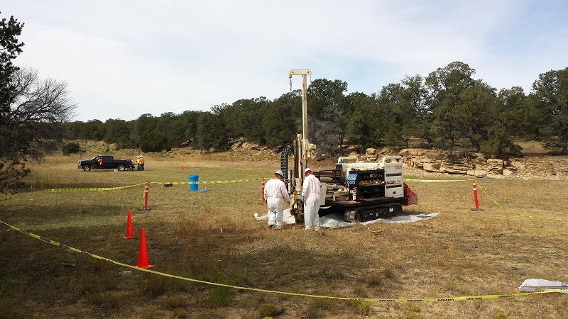
Western Nuclear investigated the mines by sampling soils on the surface and under the ground and by scanning with a radiation detector. The two mines have approximately 200,000 cubic yards of mine waste containing radium and uranium at levels that could pose a health risk. The mine waste is primarily buried in the waste piles at the sites, with very little waste scattered outside of the piles.

Next Steps

In coordination with Navajo Nation Environmental Protection Agency (NNEPA), Western Nuclear, Inc. (the company responsible for the mining operations and cleanup) and the affected community, EPA has evaluated potential options to address the hazards posed by the mine waste. The evaluation is presented in a report called the Engineering Evaluation/Cost Analysis (EE/CA).

Community Involvement

Contacts

Remedial Project Manager

Ali Oppelt
(oppelt.alexandra@epa.gov) 
(415) 972-3131 

Community Involvement Coordinator

Priscilla Tom 
(tom.priscilla@epa.gov)
(505) 240-0093

Residents of the Smith Lake Chapter and other surrounding areas, have a say in what EPA is doing in their community.  EPA works with community members and gives them the opportunity to become involved in EPA’s activities and help shape decisions made that affect their community.

Who is the Community?

Ruby Mines are located in the Smith Lake Chapter of the Navajo Nation, approximately 8 miles north of Thoreau, N.M. There are three homes located approximately one-quarter mile from Ruby Mine #1 and several homes located approximately one mile from Ruby Mine #3.

EPA Current Community Involvement Activities

EPA works with Smith Lake chapter officials as well as community members for all outreach activities and information sessions. To keep the community informed, EPA:
  • Developed a Community Involvement Plan;
  • Meets with people living nearest the mines in their homes;
  • Distributes fact sheets describing work at the mines.
  • Attends chapter meetings.
  • Meets with chapter officials, listen to concerns, and provides updates on site work that may affect the community.

EPA Past Community Involvement Activities

EPA completed the following activities in the community:
  • EPA, NNEPA and Western Nuclear, Inc. have discussed the site at three chapter meetings in 2014 and 2015. EPA will be working with the community in 2016 to develop a Community Involvement Plan.
  • In June and July 2016, EPA and NNEPA conducted interviews for a Community Involvement Plan with chapter officials and residents.

Partnerships

EPA conducts its work in close coordination with the Smith Lake community, Navajo agencies and educational institutions, as well as other federal agencies.

Cleanup Progress Timeline

The mines were operated between 1975 and 1985. Western Nuclear consolidated the waste material into piles at the two mine sites and placed a soil cover over the waste and then revegetated the areas in 1985. This process is called reclamation.

2014-2015

Several open mine adits and vent holes at the two mine sites were closed in 2014 and 2015. Photographs are of the adit and the vent hole before and after closure.

2017

EPA plans to oversee Western Nuclear Inc., and work with NNEPA and the community to evaluate potential options to address the mine sites.

2023

EPA published an Engineering Evaluation Cost Analysis that describes potential cleanup options for the site, and opened a 60-day public comment period to receive input on the document before selecting a final cleanup option.

Site Photographs

Photographs related to the abandoned uranium mine cleanup work near Ruby Mines in the Smith Lake Chapter of the Navajo Nation, approximately 30 miles east of Gallup, NM.

Before and After
  • sign attached to barbed wire surrounding a hole in the ground reads: DANGER: HAZARDOUS MINE OPENING - STAY OUT & STAY ALIVE"

    Open Vent Hole at Ruby 1 in 2013

  • Hillside with fencing surrounding what appears to be a hole in the ground with tree roots covering the entrance of a deep hole, presumably a mine shaft entrance.

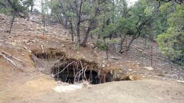
    How the adit at Ruby 1 looked prior to closure

  • Appears to be relatively natural looking landscape with wood debris from nearby forest and small tree or shrub planted.

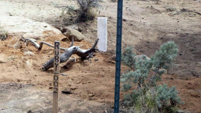
    Vent hole after closure at Ruby 1 in 2015

  • Mine entrance is closed and covered to blend in with surroundings with what apears to be trea limbs and debris matching the surrounding area.

    Adit after closure at Ruby 1 in 2015

Navajo Nation: Cleaning Up Abandoned Uranium Mines

  • Health Effects of Uranium
  • Contaminated Structures
    • Contaminated Structures Project
  • Safe Drinking Water
    • Water Sampling Results
  • Abandoned Mines Cleanup
    • Administrative Records
    • Federal Plans
      • Related Documents
    • ASPECT Aerial Survey
    • Screening Assessment Report and Atlas
    • Site Screen Reports
    • Additional Documents
    • – Central Region
      • Cyprus Amax & Western Nuclear Mines
      • Black Mesa Mining District
    • – Eastern Region
      • – Community Involvement Plan
      • – Fact Sheets
      • Ambrosia Lake Mines (Tronox)
      • Cyprus Amax & Western Nuclear Mines
      • Mac and Black Jack Mines
      • Mariano Lake Mine
      • Northeast Church Rock Mine
      • Old Church Rock Mine
      • Quivira Mines (NEW!)
      • Ruby Mines
      • Section 32/33 Mines (Tronox)
    • – North Central Region
      • Skyline Mine
    • – Northern Region
      • Cove Area Mines
      • Lukachukai Mountains Mining District (LMMD)
      • Cyprus Amax & Western Nuclear Mines
    • – Western Region
      • – Community Involvement Plan
      • – Fact Sheets
      • – Maps
      • El Paso Natural Gas Mines
      • EnPro Holdings Inc.
      • Section 9 Lease Mines
    • – Tronox Mines
      • – Fact Sheets
      • – Financial Reports
      • – Northern Agency RSE Report
    • – Trust Mines
      • Fact Sheet
      • Legal Document and Settlements
      • Technical Reports
  • Working With Communities
  • Contracting With EPA
    • RAES Employment and Training Reports
Contact Us
Contact Us to ask a question, provide feedback, or report a problem.
Last updated on December 18, 2024
  • Assistance
  • Ayuda
  • Arabic
  • Chinese (simplified)
  • Chinese (traditional)
  • Aide
  • Asistans
  • Korean
  • Assistência
  • Russian
  • Tulong
  • Vietnamese
United States Environmental Protection Agency

Discover.

  • Accessibility Statement
  • Budget & Performance
  • Contracting
  • EPA www Web Snapshot
  • Grants
  • No FEAR Act Data
  • Plain Writing
  • Privacy
  • Privacy and Security Notice

Connect.

  • Data
  • Inspector General
  • Jobs
  • Newsroom
  • Regulations.gov
  • Subscribe
  • USA.gov
  • White House

Ask.

  • Contact EPA
  • EPA Disclaimers
  • Hotlines
  • FOIA Requests
  • Frequent Questions

Follow.