U.S. flag

An official website of the United States government

Here’s how you know

Dot gov

Official websites use .gov
A .gov website belongs to an official government organization in the United States.

HTTPS

Secure .gov websites use HTTPS
A lock (LockA locked padlock) or https:// means you’ve safely connected to the .gov website. Share sensitive information only on official, secure websites.

Emergency

This is not the current EPA website. To navigate to the current EPA website, please go to www.epa.gov. This website is historical material reflecting the EPA website as it existed on January 19, 2025. This website is no longer updated and links to external websites and some internal pages may not work. More information »

    • Environmental Topics
    • Air
    • Bed Bugs
    • Cancer
    • Chemicals, Toxics, and Pesticide
    • Climate Change
    • Emergency Response
    • Environmental Information by Location
    • Environmental Justice
    • Greener Living
    • Health
    • Land, Waste, and Cleanup
    • Lead
    • Mold
    • Radon
    • Research
    • Science Topics
    • Water Topics
    • A-Z Topic Index
    • Laws & Regulations
    • By Business Sector
    • By Topic
    • Compliance
    • Enforcement
    • Laws and Executive Orders
    • Regulations
    • Report a Violation
    • Environmental Violations
    • Fraud, Waste or Abuse
    • About EPA
    • Our Mission and What We Do
    • Headquarters Offices
    • Regional Offices
    • Labs and Research Centers
    • Planning, Budget, and Results
    • Organization Chart
    • EPA History
    • Staff Directory

Breadcrumb

  1. Home
  2. Navajo Nation: Cleaning Up Abandoned Uranium Mines
  3. Abandoned Mines Cleanup
  4. – Western Region

Section 9 Lease Mines

Public Comment Opportunity

On November 23, 2024, in a public meeting, EPA released the final Section 9 Lease Mines Engineering Evaluation/Cost Analysis (EE/CA) (pdf) with a recommended cleanup alternative for the Section 9 Lease Sites. The release of the final EE/CA begins a 60-Day Public Comment Period for the EE/CA that will end January 22, 2025. Public comments can be received during the public meeting, or by email or post mail until the end of the public comment period.

Submit comments to:
Email: Estrella Armijo
(armijo.estrella@epa.gov)
Post Mail:
U.S. Environmental Protection Agency
2255 N. Gemini Drive Building No. 3
Flagstaff, Arizona 86001-1637
Attn: Section 9 Comments

Learn More:
  • EPA Fact Sheet: Recommended Cleanup Alternative for Section 9 Lease Mine Sites (pdf) (1.39 MB, November 2024)
    Fact sheet with information about the recommended cleanup alternative for the Section 9 Lease abandoned uranium mine sites.

The Section 9 Lease Mines are three abandoned uranium mine sites located near the Little Colorado River in Northern Arizona. The mines are located just outside the Navajo Nation and are about 10 miles southeast of Cameron, AZ. Under a 2016 Administrative Order on Consent, Babbitt Ranches agreed to perform a Removal Site Evaluation on the two mines on their property.

Background | Documents | Contact | Cleanup Progress | Photos

Background

Site Facts
  • The Section 9 Lease mines are three separate abandoned uranium mines.
  • The remnants of a concrete structure called an “upgrader” remain on the furthest north site. This site is also a “priority mine”.
  • Babbitt Ranches is responsible for the mines on their property.
Site Documents
  • Maps
  • Fact Sheets (Western AUM Region)
  • Technical Reports
  • Legal Documents and Settlements
Site Contacts

Remedial Project Manager
Estrella Armijo

(armijo.estrella@epa.gov)
(415) 972-3859

Community Involvement Coordinator
Elsa Johnson

(johnson.elsa@epa.gov)
(415) 947-3552

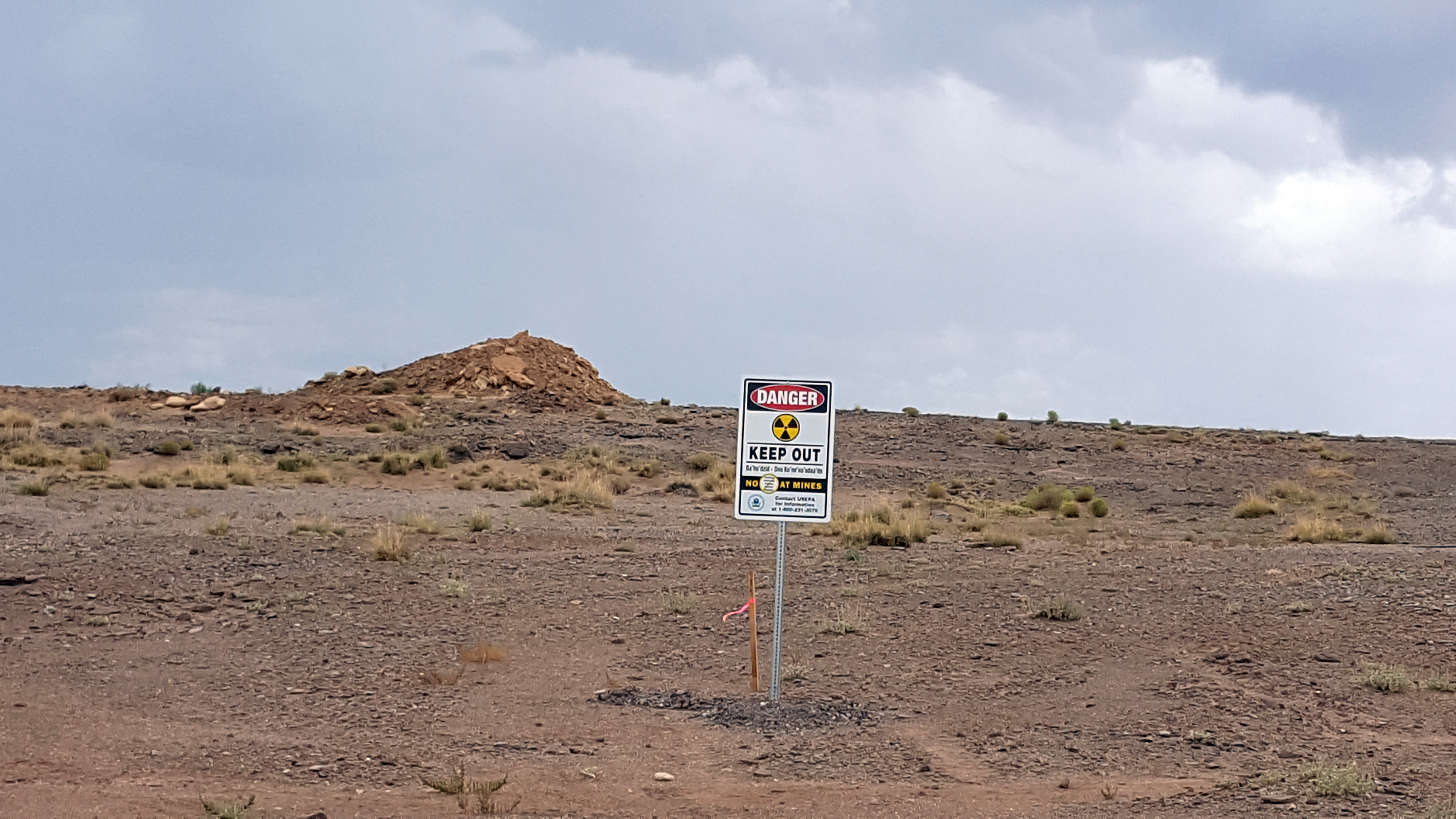
The Section 9 Lease Mines were operated in the late 1950s and early 1960s and include Abandoned Uranium Mines (AUM) 457, 458, and 459. The mines are located about 10 miles southeast of the Cameron, AZ, and are away from population centers. AUM 457, the farthest north of the three sites, also includes a concrete structure called an “upgrader”, which was meant to increase the concentration of uranium in the ore from local mines. AUM 457 is a priority mine site based on its potential impacts on the Little Colorado River.

In 2016, EPA signed a legal agreement called an Administrative Order on Consent with Babbitt Ranches. In this document, Babbitt Ranches agreed to place warning signs and perform an assessment called a Removal Site Evaluation on AUMs 457 and 458. AUM 458 is entirely on Babbitt Ranches property, while AUM 457 is partially on Babbitt Ranches property and partially on land administered by the Bureau of Reclamation. Babbitt Ranches also agreed to investigate whether contamination from AUM 459 is now located on their property.

EPA and Babbitt Ranches will continue to work with local officials to identify community members with Homesite Leases and Grazing Permits near the site, and to keep them updated on site activities. EPA is also committed to providing information to Cameron Chapter officials and other interested individuals.

Current Field Work

Babbitt Ranches began field work on the Section 9 Lease Mines in 2017, under EPA oversight. Field work to date includes:

  • Biological and Cultural Resource Surveys
  • Placing warning signs at the sites
  • Gamma radiation scanning
  • Background study

Cleanup Progress Timeline

The Section 9 Lease mines were operated in the 1950s and 1960s. Under the 2016 Administrative Order on Consent, Babbitt Ranches agreed to perform assessments at the two abandoned uranium mine sites on their property. Learn about recent and upcoming activities in the timeline below.

2024

  • EPA is in the decision-making phase for AUM457 and AUM458 (Section 9 Lease Mine Sites on Babbitt Ranches land).

2017

  • Babbitt Ranches completes cultural and biological clearances ahead of site work
  • Babbitt Ranches places warning signs at the sites
  • Babbitt Ranches begins gamma radiation and background studies

2016

EPA signs a legal agreement with Babbitt Ranches to perform assessments on mines on their property

2014

EPA completes a Site Inspection of the Section 9 Lease abandoned uranium mines

2012

DANGER - KEEP OUT with radiological symbol.
A warning sign placed in front of a waste pile at AUM 457.

EPA completes a Preliminary Assessment of the Section 9 Lease abandoned uranium mines

Site Photographs

The Section 9 Lease Mines are three abandoned uranium mines sites located near the Little Colorado River in Northern Arizona. The mines are located just outside the Navajo Nation and are about 10 miles southeast of Cameron, AZ. Under a 2016 Administrative Order on Consent, Babbitt Ranches agreed to perform a Removal Site Evaluation on the two mines on their property.

Section 9 Lease Mines
  • Desert landscape with small hills

    One of the waste piles remaining on site at AUM 457.

  • Desert vista with "Warning: Keep Out" sign, concrete wall in mid photo and concrete pad in foreground

    A warning sign placed near the upgrader structure on AUM 457.

  • DANGER - KEEP OUT with radiological symbol.

    A warning sign placed in front of a waste pile at AUM 457.

  • Warning sign in sandy soil in front of brush with opposite bank of river visible in the distance.

    Warning sign placed near the Little Colorado River.

  • Concrete walled structure in a desert setting

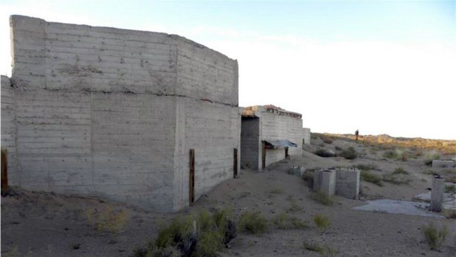
    The remnants of a concrete structure called an “upgrader”, which was meant to increase the concentration of uranium in the ore from local mines.

Navajo Nation: Cleaning Up Abandoned Uranium Mines

  • Health Effects of Uranium
  • Contaminated Structures
    • Contaminated Structures Project
  • Safe Drinking Water
    • Water Sampling Results
  • Abandoned Mines Cleanup
    • Administrative Records
    • Federal Plans
      • Related Documents
    • ASPECT Aerial Survey
    • Screening Assessment Report and Atlas
    • Site Screen Reports
    • Additional Documents
    • – Central Region
      • Cyprus Amax & Western Nuclear Mines
      • Black Mesa Mining District
    • – Eastern Region
      • – Community Involvement Plan
      • – Fact Sheets
      • Ambrosia Lake Mines (Tronox)
      • Cyprus Amax & Western Nuclear Mines
      • Mac and Black Jack Mines
      • Mariano Lake Mine
      • Northeast Church Rock Mine
      • Old Church Rock Mine
      • Quivira Mines (NEW!)
      • Ruby Mines
      • Section 32/33 Mines (Tronox)
    • – North Central Region
      • Skyline Mine
    • – Northern Region
      • Cove Area Mines
      • Lukachukai Mountains Mining District (LMMD)
      • Cyprus Amax & Western Nuclear Mines
    • – Western Region
      • – Community Involvement Plan
      • – Fact Sheets
      • – Maps
      • El Paso Natural Gas Mines
      • EnPro Holdings Inc.
      • Section 9 Lease Mines
    • – Tronox Mines
      • – Fact Sheets
      • – Financial Reports
      • – Northern Agency RSE Report
    • – Trust Mines
      • Fact Sheet
      • Legal Document and Settlements
      • Technical Reports
  • Working With Communities
  • Contracting With EPA
    • RAES Employment and Training Reports
Contact Us
Contact Us to ask a question, provide feedback, or report a problem.
Last updated on December 30, 2024
  • Assistance
  • Ayuda
  • Arabic
  • Chinese (simplified)
  • Chinese (traditional)
  • Aide
  • Asistans
  • Korean
  • Assistência
  • Russian
  • Tulong
  • Vietnamese
United States Environmental Protection Agency

Discover.

  • Accessibility Statement
  • Budget & Performance
  • Contracting
  • EPA www Web Snapshot
  • Grants
  • No FEAR Act Data
  • Plain Writing
  • Privacy
  • Privacy and Security Notice

Connect.

  • Data
  • Inspector General
  • Jobs
  • Newsroom
  • Regulations.gov
  • Subscribe
  • USA.gov
  • White House

Ask.

  • Contact EPA
  • EPA Disclaimers
  • Hotlines
  • FOIA Requests
  • Frequent Questions

Follow.